Angletarn Pikes Walk | Lake District Walks
This circular route to Angletarn Pikes can be completed in one day or combined with an overnight camp at the tarn. Honestly, if the weather is right it makes total sense to stay up there and take a dip!

This walk to Angletarn Pikes approaches the tarn from a less travelled direction, Martindale. Most people approach Angletarn from either Hartsop or Patterdale with a number of viable routes. I enjoy the route from Martindale for its more steady approach with only a short steep section towards the end.
WALK OVERVIEW
Start - Martindale
Park at St Martins Church in Martindale. There is parking at St Peters nearby if this area is full.
Distance - 7.37 miles
Duration - 4-5hrs
Difficulty - Moderate
Total Ascent - 592m
Map - You can find my full route here on Ordnance Surveys’ website

PREPARING FOR YOUR ANGLETARN PIKES WALK
NAVIGATION
As with all good walk preparation, you will need a way to navigate on your walk. I use the OS Maps App on my phone and you can find my route here
If you are navigating using your phone be sure to do the following;
Download the map before you leave wifi - you CANT guarantee you will have signal in the mountains.
Bring a battery pack or way to charge your device.
Print a copy of the walk before you leave from the Ordance Survey Website as a back up.
I also use my Suunto Watch as a backup navigation tool, however, if you are not confident that your technology will last you should purchase the Ordnance Survey Map for your walk.
WEATHER
If there is one thing that is for certain when walking in the British Mountains is that you can never be sure of the weather. Even on days that are forecast glorious sunshine, it is best to be prepared for the worst, as conditions can change rapidly.
Check the latest Angletarn Pikes weather here
WHAT TO WEAR
When hiking in the UK it is important to remain flexible and with this in mind layers are certainly your best option. Mountain environments can be unforgiving and weather can change quickly. It is normal to see winds increasing and temperatures dropping as you reach your chosen summit. Make sure to pack a spare layer for the summit.
Suitable footwear in the form of walking boots or shoes is advised, especially when conditions are less than ideal. A good pair of walking boots will offer your ankles support, keep your feet dry and ensure you have grip, especially on those wet days. Yes, you probably could make it to the top in that old pair of tennis trainers… but will your feet thank you?
WHERE TO START
Getting to the start of the walk involves driving down some narrow country roads towards Howtown and Martindale from Pooley Bridge. Be careful as traffic can be busy at peak times and there are few places to pass. It is important to keep an eye out for the last passing place as it is not uncommon for you to need to reverse back down the road.
The postcode for Howtown if you are using your Sat Nav is CA10 2LZ and this should lead you to the Howtown Pier. Parking is possible by the Pier on the roadside but this is limited.
If you fancy a cool alternative to access Howtown consider taking a trip on the Ullswater steamers.
Parking is also possible by St Peter’s Church in Martindale. The church sits at the base of the paths to Hallin Fell and Steel Knotts so is ideally located. This area can become busy so be sure to head up early or late to guarantee a parking spot.
Parking in both Howtown and Martindale is free but be sure to be considerate of other road users. The road is used by farm vehicles and blocking it could result in your car getting ‘bumped’ by a tractor.
FACILITIES
Unlike more popular areas of the Lake like Keswick and Windermere there are no facilities in Howtown and Martindale, besides the Howtown Hotel. To me this is a positive as it draws less people but it is worth noting you should be prepared for a wild wee if you get caught short.
Parking is also possible by St Peter’s Church in Martindale. The church sits at the base of the paths to Hallin Fell and Steel Knotts so is ideally located. This area can become busy so be sure to head up early or late to guarantee a parking spot.
Parking in both Howtown and Martindale is free but be sure to be considerate of other road users. The road is used by farm vehicles and blocking it could result in your car getting ‘bumped’ by a tractor.
FACILITIES
Unlike more popular areas of the Lake like Keswick and Windermere there are no facilities in Howtown and Martindale. To me this is a positive as it draws less people but it is worth noting you should be prepared for a wild wee if you get caught short.
MARTINDALE TO ANGLETARN PIKES CIRCULAR WALK
Starting your walk in Martindale, you should take the road that leads towards Beda Fell and away from St Martins Church. You will be keeping to this road for a while as it winds its way alongside Bannerdale Beck. Keeping Steel Knotts to your left and Beda Fell to your right the road leads towards The Nab as it stands imposingly in the Deer conservation area. This walk is a fantastic one for spotting the local deer grazing as you approach the end of this road.
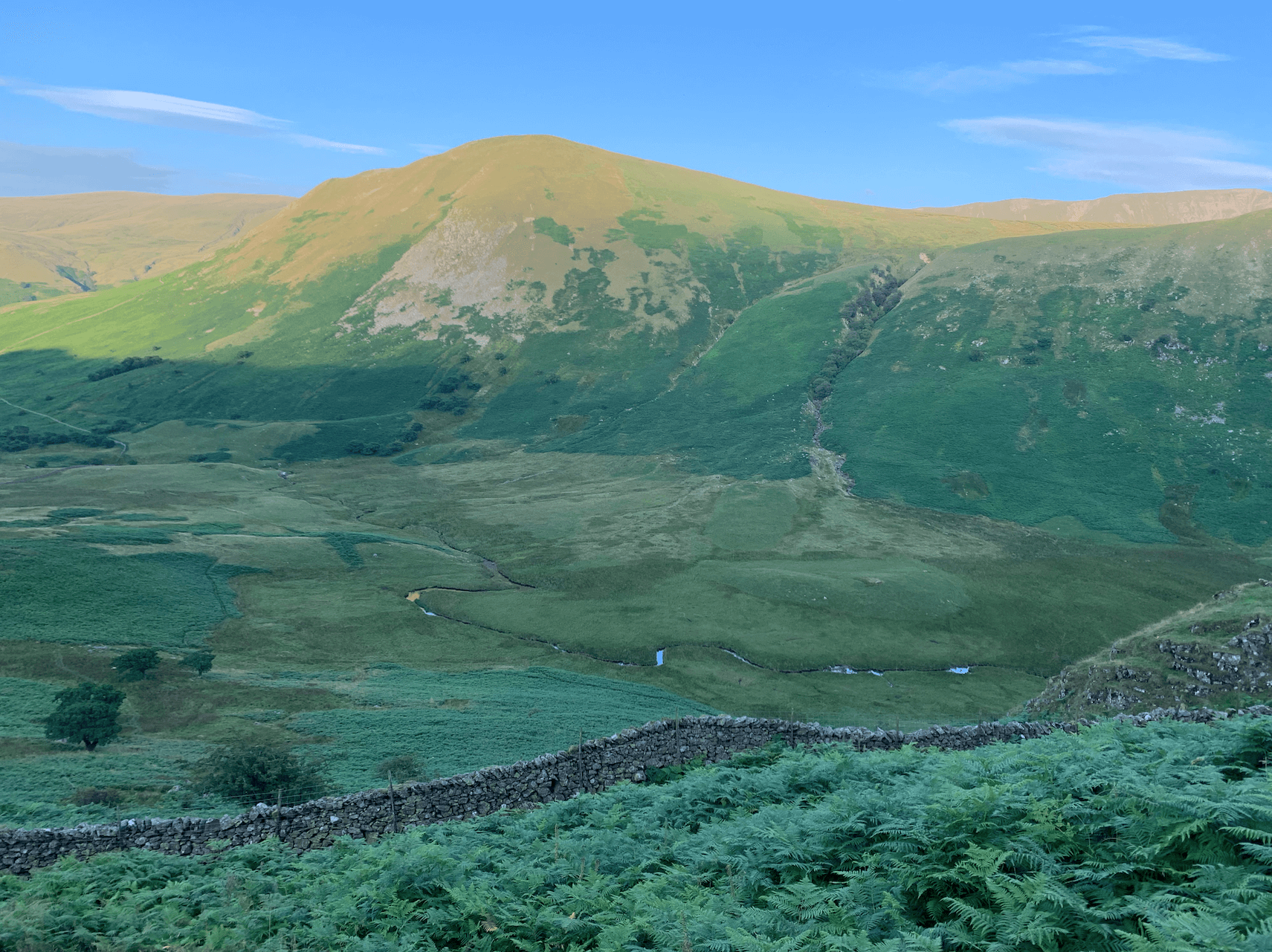
Looking across to The Nab from under Heck Crag
When you reach the farm at Dale Head, take the path to the right which leads up towards Heck Crag. This part of the walk can be overgrown in the summer, check this video (5:06) however the path is still well defined. From Dale Head there is a steady incline as you follow the stone wall all the way to the base of Heck Crag. The final approach gets a bit steeper as you earn your approach to Angletarn, don’t worry the scenery at Angletarn is worth it.

View of my tent pitch at Angletarn
If you have the time and the weather stopping the night at Angletarn makes perfect sense. The opportunity to spend the evening by the tarn and take a wild swim is a must. However all good things come to an end and when it is time to descend back to Martindale you can complete this circular route by leaving Angletarn towards Boredale Hause. Boredale Hause is somewhat of a crossroads and from here you can descent to Patterdale or head up towards Place Fell. If you are continuing my route back towards Martindale you will descend through Boredale keeping the Boredale Beck on your right this time.
Similar to your route up you will eventually find yourself doing some road walking until you head up and over Howstead Brow at the base of Beda Fell. From here it will be a short amble back to your car.
When walking the path up it is essential to take time to turn around and look at the scenery behind you. The views back towards the Martindale Horseshoe are impressive, letting your mind run away with the many possibilities of walking routes in the area. It was on this part of the walk that I decided to make Beda Fell Episode 2 in #mywainwrightsproject

ANY QUESTIONS?
Be sure to leave any questions in the comments and I will try my best to help you with your Angletarn Route. If you found this post useful and want to support me to make future content consider using the QR code to Buy Me A Coffee. All proceeds go towards supporting this website.
Thanks for stopping by and while you are here why don’t you check out some related posts below.

